Data Annotation

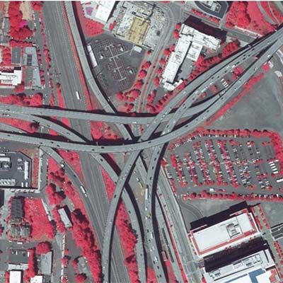
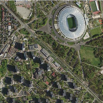
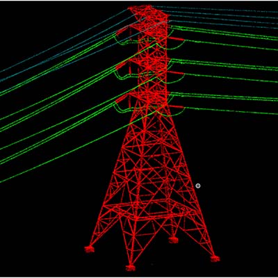
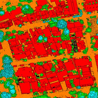
Data Annotation At the core of intelligent geospatial analysis lies the precision of data interpretation — and that’s exactly where our GIS Data Annotation services excel. We provide high-quality, accurate annotation of geospatial data to support AI/ML model training, urban planning, environmental monitoring, and infrastructure development. By adding semantic context and spatial intelligence to raw…

GIS Utility Mapping

GIS Utility Mapping Our GIS Utility Mapping services deliver accurate, high-resolution spatial data for the effective management of underground and aboveground utility networks. We specialize in mapping water, sewer, gas, electric, and telecom infrastructure using advanced survey technologies, including GPS, LiDAR, and remote sensing. Our comprehensive mapping solutions support asset inventory, condition assessment, and regulatory…

GIS Telecom

GIS Telecom Our GIS Telecom services empower utility providers with precise spatial data to plan, design, and manage telecommunication networks efficiently. We deliver accurate mapping and data integration solutions that support network planning, asset management, and field operations. From fiber optic layouts to wireless infrastructure planning, our GIS solutions enhance decision-making, reduce operational costs, and…

Vegetation Management ​

Vegetation Management Electricity is a major lifeline of the world, but sometimes, encroachments of vegetation growth, along with other factors, can create difficulties in power supply. Traditional electrical power line inspections have the disadvantages of high labor intensity and low efficiency.  Vegetation management involves removing, controlling, and managing large trees, plants, and other bushes to…

UM/319/2020/BIM

UM/319/2020/BIM Duration: 1200 Hours Year: 2020 Area : 5 x 660 = 3300m2 Total Manpower : 10 Location: USA Service Type: BIM LOD: 300 Objective Objective of the project is to model all the Architectural, Structural, MEPFP need to be modeled in Revit 2020. Inputs Point cloud data in .rcp format with all supporting files.…

UM/297/2020/BIM

UM/316/2020/BIM Duration: 50 Hours Year: 2019 Area : 360 m2 Total Manpower : 2 Location: USA Service Type: BIM LOD: 250 Objective Objective of the project is to  Model the building internals and externals in Revit. Inputs Point cloud data in .rcp format with all supporting files. Revit template. 360° photos Scope The Scope of…

UM/325/2020/Orthophoto

UM/316/2020/Orthophoto Duration: 10 weeks (1800 Hours) Year: 2020 Area : 845 km2 Total Manpower : 8 Location: Poland Service Type: Orthophoto Objective The objective of the project is to  Edit and Update the existing DTM and Generation 4cm  4-Band Orthophoto Tiles. Inputs 14000 Raw images AT results LiDAR DTM Scope The Scope of the project…

UM/316/2020/Orthophoto

UM/316/2020/Orthophoto Duration: 8 weeks (2600 Hours) Year: 2020 Area : 2360 km2 Total Manpower : 10 Location: Poland Service Type: Orthophoto Objective Objective of the project is to  do Aerial triangulation, Generation of 1m DTM  and 5cm Orthophotomaps. Inputs 32000 Raw images EO parameter Camera Details GCPs Scope The Scope of the project included the…

UM/270/2019/LiDAR

UM/314/2020/LiDAR Duration: 4 weeks (1200 Hours) Yaer: 2020 Length : 500 Miles Total Manpower : 10 Location: USA Service Type: LiDAR Objective The objective of the project to classify all Power line related structures. Inputs Calibrated raw point cloud in LAS format Tile layout in DGN format Point Class file in PTC format Orthophoto In…

UM/314/2020/LiDAR

UM/314/2020/LiDAR Duration: 12 weeks (1800 Hours) Yaer: 2020 Area : 1500 km2 Total Manpower : 8 Location: Germany Service Type: LiDAR Objective The objective of the project is to classify the LiDAR data for low points and air points filtered and the ground Classified using automated Terrascan algorithms. However, the data required Validation and editing…